Yesterday, a very rare event took place, the current Pope, Benedict XVI resigned. He is the second Pope I knew at his life time, after the most popular John Paul II, and the 8th in the history of popes who originated from Germany, or what you would call the respective country of the time. For me, this is a most attractive occasion to dive a little bit into the history of Papacy. What was certainly often said in the media was that the resignation of a pope last happened in the year 1294 by Pope Celestine V.
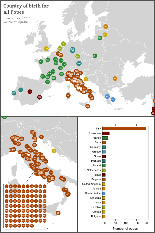
There may be various reasons for Pope Benedict to take this rare step, such as age, the abuse scandals of the catholic church or power plays within the Curia itself. The announcement to resign came very surprising, nevertheless, and since then rumours about the successor on the Holy See have arisen. Some of the rumours say, the next Pope should originate from the developing world, where the number of followers to the catholic church increased most. With the upcoming decision in mind, it’s time for a retrospection. The list of Popes from wikipedia helped to plot this map of birth places (if it is known) of all 266 former Popes.
The Popes are consecutively numbered from the first (Peter) to the most recent (Benedict XVI). We can see that almost all Popes originated from Europe except some ancient Popes from the Middle East, including the apostle Peter who was ‘founder’ of the Roman catholic church. The overwhelming majority of Popes was born in what is now the country of Italy. This is surprising, since Italy is a very young country (finally united 1870) and I would have guessed the Popes arose from the former Vatican state, whose borders changed a lot during the centuries but were generally smaller than the modern state (historical overview and maps here). Among the Italian Popes, a striking number of 87 Popes originated directly from Rome. With this in mind, I think it’s time for a change (although I’m neither catholic nor religious in any way). Let’s cross our fingers for a black Pope! And while we are at it, maybe he’s gay too.
The map was created with R just as described in previous posts. Unfortunately the wikipedia article only gives names of birth places, no coordinates. I needed to find a workaround to plot the symbols on the map, and the solution was the geonames package, which provides an interface for the geonames.org database. With this, you just issue a search with the string you want to retrieve coordinates from, and obtain a list of hits with accompanying data. In the example below I constricted the search to Europe and the Class to “P” and “A” which stands for cities and countries, respectively.
# FeatureClass "P" for city,village, "A" for country,state,region
getLoc <- function(loc) {
query <-GNsearch(name_equals=loc ,continentCode=list("EU"), featureClass="P", maxRows=1)
query[1,c("name", "countryName", "lat", "lng")]
}

# Example
getLoc("Rome")

So I guess the numbers indicate the number of the pope in question, the highest number indicating the most recent pope?
That’s exactly right!
Just added it to the text, thanks for the hint.